Greater Wellington is actively providing flood protection work in the region, which includes building and maintaining stopbanks, providing flood ways and drainage, opening of Lake Ōnoke, using the barrage gates to manage flow, keeping river channel clear of blockages and stabilising land through planting efforts.
In the 1960’s a comprehensive land development and flood control scheme for the whole district was implemented, via river diversion, defined flood way paths, barrage gates and drainage outlets. The ability to maintain an efficient, lasting outlet from Lake Ōnoke to the sea has been critical for flood prevention in the Lower Wairarapa Valley, as have flood paths to contain and direct overflow from the Ruamāhanga river to Lake Wairarapa. The implementation of the scheme has had a significant impact on environmental and social issues in the region.
The total catchment area protects over 41,000 hectares, including agricultural land, homes and businesses.
Our flood protection infrastructure may be affected in the years to come by climate change, sea level rise, sinking ground or seismic activity causing ground level rise and possible liquefaction of barrage gate foundations, as well as sediment and gravel deposits in the rivers, lakes and at the Lake Ōnoke mouth.
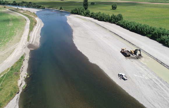
One of the tools in river management is extracting or moving sand and gravel deposits, to adjust the flow of rivers to reduce the effects of erosion and flooding. Greater Wellington only undertakes extraction for river management purposes, and not to support commercial enterprise.
We mainly use diggers and trucks when working in the river corridor, although sometimes a bulldozer may be used. Gravel bars create flood risk, especially when the outlet from Lake Ōnoke to the sea blocks up.
Water levels at Lake Ōnoke, the barrage gates, Lake Wairarapa and the rivers across the Lower Valley are constantly monitored.
We only use engineering methods in the rivers when absolutely necessary, doing our best to limit work outside of the water and to minimise impact to the natural environment.
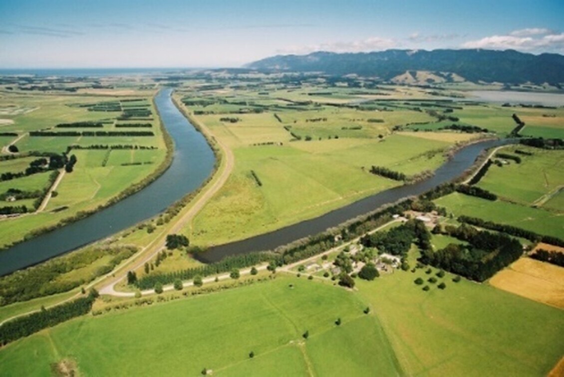
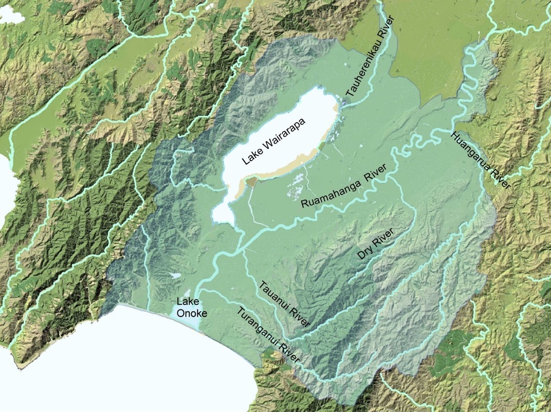
The Ruamāhanga river travels from the northern central Tararua Range through open country across the eastern side of the Wairarapa plains to Lake Wairarapa and Lake Ōnoke. The Lower Valley area covers from the Waiohine confluence to the Lake Ōnoke outlet. Other major tributaries include the Tauwherenīkau draining from the western Tararua Ranges include the Tauwherenīkau River draining from the western hills and the Huangarua, Tauanui and Turanganui Rivers flowing from the eastern hills. These rivers all flow through vast areas of farmland and are therefore susceptible to run-off particularly from dairy farms and disturbances from stock entering the river channel.
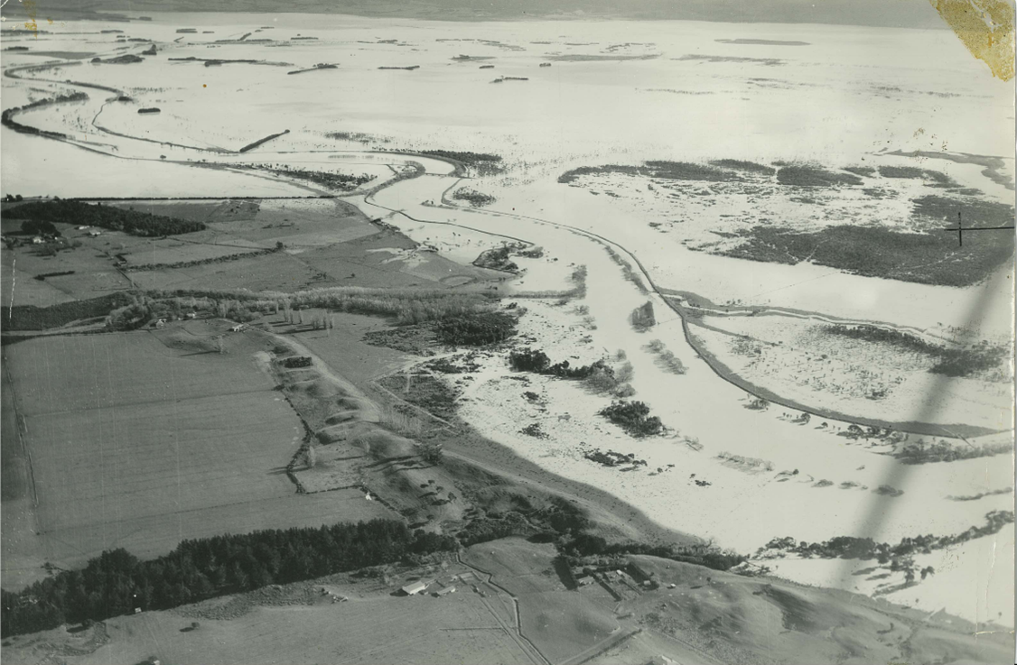
The Lower Wairarapa Valley system also includes Lake Ōnoke and Lake Wairarapa. Before the Lower Wairarapa Valley Scheme, a major flood could affect up to 20,000ha of land, with some areas being flooded eight times a year. Roads were blocked for days on end, communication lines damaged, and fences destroyed. Despite an efficient flood warning service which began in the 1950s, stock losses at times were severe.
The Lower Wairarapa Valley Development Scheme is one of New Zealand's largest and most ambitious land development and flood control schemes, benefiting a total land area of 41,000 hectares. Greater Wellington is responsible for the implementation and maintenance of the scheme.
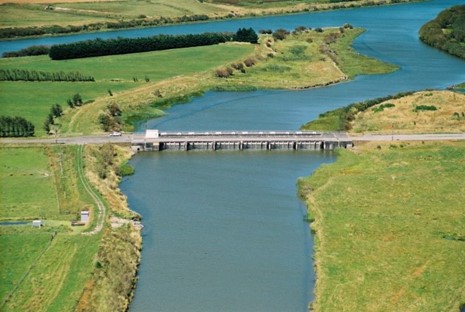
The Ruamāhanga River was diverted from its direct course into Lake Wairarapa, across the Kumenga Peninsula and into the Lower Ruamāhanga. The barrage control gates largely prevent all normal flows of the Ruamāhanga from entering Lake Wairarapa.
The barrage has also enabled levels of Lake Ōnoke to be raised quickly to either overcome impending blockage of the outlet or to aid in the formation of a new opening. This also means that the lake can be kept at a low level, ready to accept any flows from the Oporua Floodway. Such flows are the result of the overflow of flood discharges from the Ruamāhanga River at various points further upstream. Flow size is dependent on the size of the flood event and cannot be controlled.
The ability to be able to maintain an efficient and ever-lasting outlet from Lake Ōnoke to the sea has been a key aspect of preventing flooding in the Lower Wairarapa Valley. The flood protection works were tested in the major floods of 2004 and they held up well despite the extreme conditions.
The land-use patterns and environment of the Lower Wairarapa Valley are now well-established. Our aim is to allow for improvements in the quality and security of this environment. If you want more information about the scheme please contact Greater Wellington on 0800 496 734.
Greater Wellington has initiated a future-focused review of the Lower Wairarapa Valley Development Scheme.
The purpose of this review is to work with mana whenua, farmers who rely on the Scheme, and the wider community, to co-design a sustainable catchment strategy for the Lower Wairarapa Valley by collecting and sharing the information needed to support informed decision-making.
Why now?
At present, we don’t know how the Scheme will perform in light of climate change. We have also noticed growing challenges with parts of the Scheme given its age and changes to flood management best practise.
Following recent Treaty settlements, mana whenua are vested owners of significant lands in and around the scheme area, including the bed of Lake Wairarapa.
Also, the Ruamāhanga Whaitua Implementation Programme, adopted by Council in 2019, includes recommendations to explore significant changes to the Scheme, such as adjustments to lake levels and re-connect the Ruamāhanga river back into Lake Wairarapa.
Where are we at?
While there is some existing information about the catchment, there is a lot to be uncovered about the performance and impacts of the Scheme.
Initially Greater Wellington will be working to establish and share high-quality information to support decision-making, before options for future management are looked at. This will include flood hazard modelling and enhanced monitoring of key environmental indicators.
Practical work needs to continue on the ground, so we are still investing in flood protection works and wetlands restoration through initiatives such as planting and predator control.
We will be working with the wider community during 2026 and 2027 to help build understanding of environmental changes and the performance of the Scheme for flood protection purposes.
There is a long, history around the Wairarapa Moana and the flood management systems that are in place today. Mana whenua recall the time when the lakes doubled, the sandspits closed over and the rains filled the Wairarapa plains. For Māori this was referred to as the hinurangi. And inundation of water when eels migrate. For Farmers it meant flooding, so they opened the sandspit. Today this is knows as “The Battle of the Lakes” and you can learn more here:
This video was made by Ngāti Kahungunu ki Wairarapa, who have a deep connection to the Wairarapa and its wetlands. You can also visit their website, Wairarapa Glistening Water, to hear and learn more from tangata whenua within the area.
Flooding has always been a feature of the Lower Wairarapa. Almost from the first day of their settlement in the district around 1840, the new inhabitants experienced its severity. They considered the richness of the land compensated for the inconvenience of flooding.
As settlement became denser, a Wairarapa River Board was set up in 1886 in a communal attempt to reduce flooding. The main responsibility was the maintenance of a reasonable outlet through the shingle bar which separates Lake Ōnoke from the open sea of Palliser Bay.
With the limited means available, the lake had to reach a high level before an opening would be successful. This meant that large areas of valuable land in the Lower Wairarapa were unproductive in those early days.
Over the years, in addition to lake opening, the River Board carried out isolated stopbanking works and erosion protection schemes to generally improve conditions for landowners.
The Wairarapa Catchment Board - formed in the 1940s - was a body which had sufficient authority and statutory responsibility to plan and implement a major flood protection scheme for the Lower Wairarapa Valley.
However, a comprehensive flood control scheme for the whole district was not realised until the 1960s. Several major schemes were proposed previously but had never come to fruition. The last of these was proposed in 1948 with the aim of soldier rehabilitation farm creation, but this did not proceed.
Many of the ideas from earlier proposals were incorporated in the Lower Wairarapa Valley Development Scheme which was successfully launched in 1960.
Greater Wellington has more information about the scheme and the floodplain, the risk of flooding, and what has been done to minimise its impact. We are also responsible for how the scheme will be managed in the future.
The Lower Ruamāhanga Advisory Group is a Greater Wellington Advisory Body. The Group has eight members who represent local residents, river advocates and those with sustainability interests, plus two councillors from Greater Wellington and one councillor from South Wairarapa District Council.
The Advisory Group's core role is to give advice to Greater Wellington's Environment and Climate Committee on matters relating to flood and erosion risks in the Lower Ruamāhanga area. They provide advice on a range of proposals and reports to ensure they balance cost effective flood & erosion risk management activities with environmental, cultural and recreational opportunities. Members also provide advice on how best to support wider engagement on these matters with their local community.
Lower Ruamāhanga Advisory Group Terms of Reference 2025-28